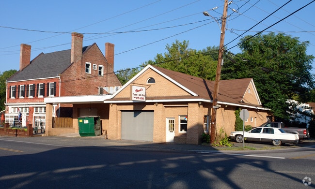
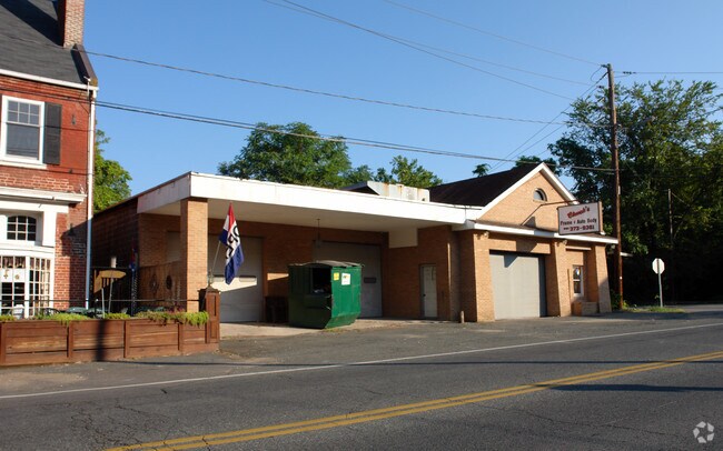
Property Record
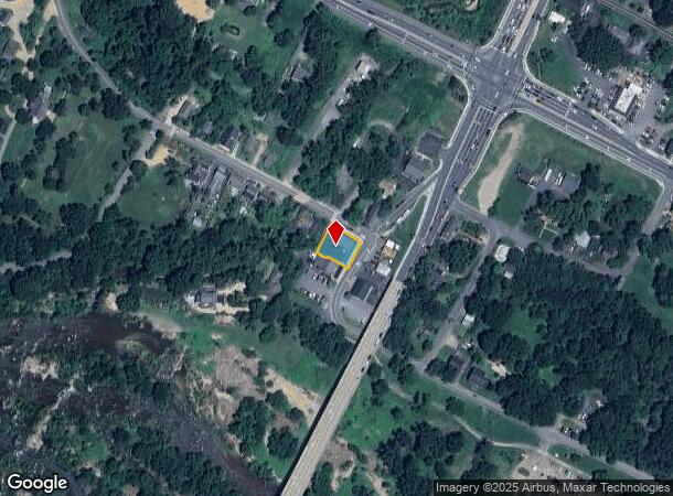
105 W Cambridge St, Fredericksburg, VA 22405
NEARBY LISTINGS FOR SALE OR LEASE
Property Detail
105 W Cambridge St
Washington-Arlington-Alexandria, DC-VA-MD-WV
Filling Station
53D-1-102
LOT 1 FILLING STATION
Autorepair
Stafford
AE
Virginia
51179C0203F
1
2024
0.19 AC
2025
Stafford County
010306
Washington, DC
5,410 SF
DEMOGRAPHICS near 105 W Cambridge St
1 Mile
3 Mile
5 Mile
2024 Total Population
4,893
56,160
100,691
2029 Population
5,384
61,226
110,541
Pop Growth 2024-2029
+ 10.03%
+ 9.02%
+ 9.78%
Average Age
40
38
38
2024 Total Households
1,974
21,635
37,404
HH Growth 2024-2029
+ 9.47%
+ 9.15%
+ 9.85%
Median Household Inc
$87,705
$84,728
$92,081
Avg Household Size
2.40
2.50
2.60
2024 Avg HH Vehicles
2.00
2.00
2.00
Median Home Value
$363,762
$375,582
$367,006
Median Year Built
1978
1991
1992
Nearby Places
Map Layers
Map Styles
 Street
 Aerial
- Restaurants
- Banks
- Shops
- Fitness
- Groceries
PUBLIC TRANSPORTATION
COMMUTER RAIL
Fredericksburg (Fredericksburg Line - Virginia Railway Express)
DRIVE
WALK
Distance
Fredericksburg (Fredericksburg Line - Virginia Railway Express)
5 min
2.3 mi
Leeland Road (Fredericksburg Line - Virginia Railway Express)
DRIVE
WALK
Distance
Leeland Road (Fredericksburg Line - Virginia Railway Express)
8 min
4.0 mi
Freight Ports
Virginia Port Authority - Richmond
DRIVE
WALK
Distance
Virginia Port Authority - Richmond
82 min
64.4 mi
Nearby Properties
Address
Land Use
TOTAL SIZE
Lot Size
Zoning
Address
Land Use
TOTAL SIZE
Lot Size
Zoning
945,573 SF
22.11 AC
PDMC
Address
Land Use
TOTAL SIZE
Lot Size
Zoning
427,478 SF
15.36 AC
PDC
Address
Land Use
TOTAL SIZE
Lot Size
Zoning
14,500 SF
CT
Address
Land Use
TOTAL SIZE
Lot Size
Zoning
343,471 SF
14.61 AC
CD
Address
Land Use
TOTAL SIZE
Lot Size
Zoning
121,832 SF
0.23 AC
R2
Address
Land Use
TOTAL SIZE
Lot Size
Zoning
282,451 SF
110.89 AC
A1
Address
Land Use
TOTAL SIZE
Lot Size
Zoning
421,851 SF
7.05 AC
PDMU
Address
Land Use
TOTAL SIZE
Lot Size
Zoning
198,000 SF
23.67 AC
R2
Address
Land Use
TOTAL SIZE
Lot Size
Zoning
271,103 SF
16.84 AC
PDC
Address
Land Use
TOTAL SIZE
Lot Size
Zoning
248,662 SF
8.56 AC
PDC
Address
Land Use
TOTAL SIZE
Lot Size
Zoning
234,016 SF
13.48 AC
PDC
Address
Land Use
TOTAL SIZE
Lot Size
Zoning
252,616 SF
22.31 AC
R16
Address
Land Use
TOTAL SIZE
Lot Size
Zoning
80,000 SF
0.51 AC
R2
Address
Land Use
TOTAL SIZE
Lot Size
Zoning
143,003 SF
38.64 AC
R2
Address
Land Use
TOTAL SIZE
Lot Size
Zoning
230,664 SF
60.21 AC
A2
Address
Land Use
TOTAL SIZE
Lot Size
Zoning
105,564 SF
1.07 AC
R2
Address
Land Use
TOTAL SIZE
Lot Size
Zoning
188 SF
14.96 AC
R2
Address
Land Use
TOTAL SIZE
Lot Size
Zoning
21.89 AC
PDC
Address
Land Use
TOTAL SIZE
Lot Size
Zoning
156,241 SF
12.73 AC
R16
Address
Land Use
TOTAL SIZE
Lot Size
Zoning
168 SF
11.77 AC
R2
Address
Land Use
TOTAL SIZE
Lot Size
Zoning
100 AC
R2
Address
Land Use
TOTAL SIZE
Lot Size
Zoning
187,097 SF
16.66 AC
R16
Address
Land Use
TOTAL SIZE
Lot Size
Zoning
76,950 SF
0.47 AC
CD
Address
Land Use
TOTAL SIZE
Lot Size
Zoning
192,485 SF
17.39 AC
R12
Address
Land Use
TOTAL SIZE
Lot Size
Zoning
610,866 SF
37.59 AC
M1
Address
Land Use
TOTAL SIZE
Lot Size
Zoning
56,004 SF
0.46 AC
R2
Address
Land Use
TOTAL SIZE
Lot Size
Zoning
164,579 SF
11.81 AC
M1
Address
Land Use
TOTAL SIZE
Lot Size
Zoning
26.99 AC
PDR
Address
Land Use
TOTAL SIZE
Lot Size
Zoning
Address
Land Use
TOTAL SIZE
Lot Size
Zoning
162,535 SF
10.67 AC
CH
The World's #1 Commercial Real Estate Marketplace
Connect with us
© 2025 CoStar Group
The information above has been obtained from sources believed reliable. While we do not doubt its accuracy we have not verified it and make no guarantee, warranty or representation about it. It is your responsibility to independently confirm its accuracy and completeness. Any projections, opinions, assumptions, or estimates used are for example only and do not represent the current or future performance of the property. The value of this transaction to you depends on tax and other factors which should be evaluated by your tax, financial, and legal advisors. You and your advisors should conduct a careful, independent investigation of the property to determine to your satisfaction the suitability of the property for your needs.